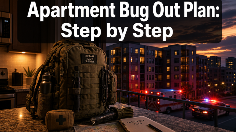
Hey there! Some links on this page may be affiliate links which means that, if you choose to make a purchase, I may earn a commission at no extra cost to you. I greatly appreciate your support. Read the full disclosure here.
Nearly 40% of Americans live in urban areas classified as high-risk for at least one major disaster type, yet fewer than one in five households has a documented evacuation plan, according to FEMA’s preparedness survey data. That gap isn’t ignorance — it’s overconfidence. Most people assume the roads will be clear, the phones will work, and someone official will tell them what to do. None of those assumptions survive first contact with a real emergency.
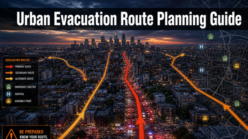
This urban evacuation route planning guide exists to close that gap. Whether you’re prepping for a hurricane, a chemical spill, a civil emergency, or a grid-down scenario, the principles here are the same: know your exits before you need them, have backups for your backups, and practice until the plan runs on muscle memory.
Key Takeaways
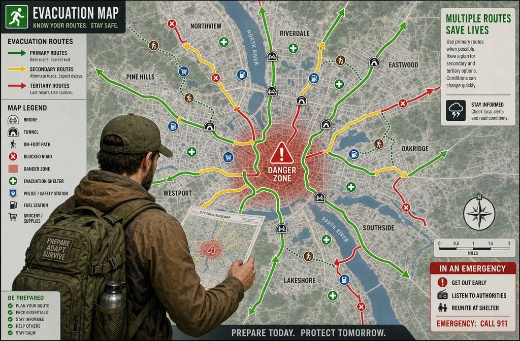
- An urban evacuation route is a pre-planned path out of a city or danger zone, and every household needs at least three options.
- Route selection changes based on the type of emergency — what works for a flood won’t work for a wildfire or civil unrest.
- The most dangerous mistake in urban evacuations is waiting too long to leave.
- People with mobility limitations, pets, or medical needs require specialized planning that standard emergency guides often ignore.
- Free tools including FEMA’s Integrated Public Alert & Warning System (IPAWS), Google Crisis Maps, and local county GIS portals can help map routes at no cost.
- Technology helps, but paper maps and a compass are non-negotiable backups.
- Emergency services coordinate evacuations through tiered zone systems — knowing your zone number can save hours of gridlock.
- A packed bug out bag and a practiced family communication plan are the two most critical physical preparations.
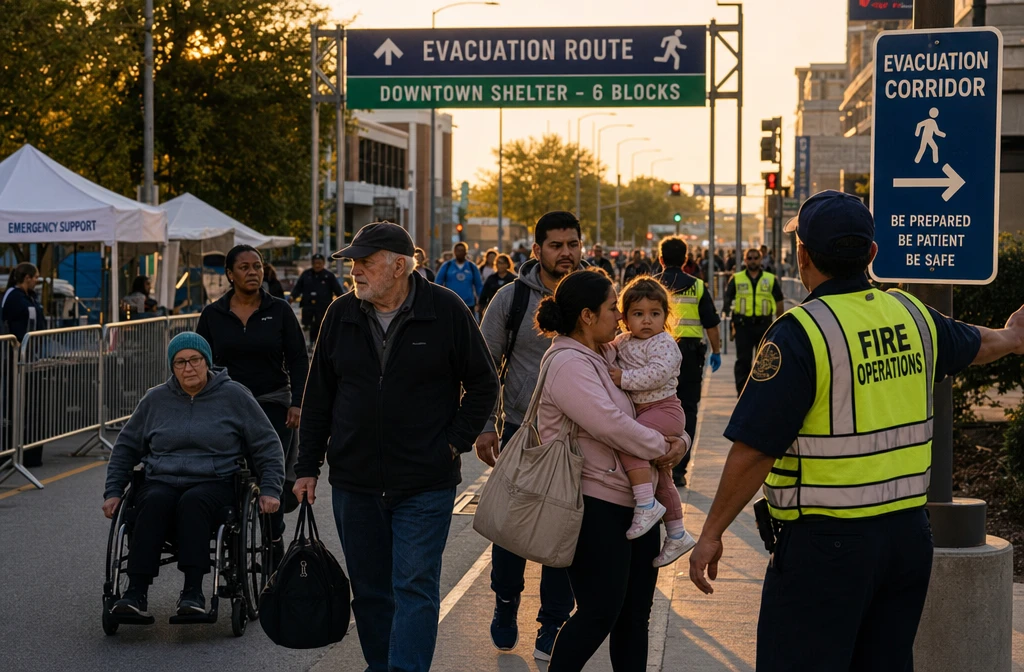
What Exactly Is an Urban Evacuation Route and Why Do You Need One?
An urban evacuation route is a pre-identified path — by vehicle, foot, or both — that moves people away from a danger zone in a city toward safety. It’s not just a highway on a map. It’s a layered system that accounts for traffic flow, bridge capacity, blocked intersections, and alternate modes of travel.
Cities don’t stay navigable during emergencies. Roads flood. Bridges close. Tunnels fill with smoke. The moment a major disaster triggers mass movement, normal traffic patterns collapse. Without a pre-planned route, most people default to the same two or three main roads — and those roads become parking lots within minutes.
Why every prepper needs this:
- Urban density means thousands of people are competing for the same exits at the same time.
- Emergency services prioritize rescue over traffic management in the first hours.
- Cell networks often fail or become overloaded, making real-time navigation unreliable.
- Knowing your route in advance reduces panic-driven decision-making, which is one of the leading causes of evacuation fatalities.
For a broader framework on getting out of the city safely, the Bug Out Route Planning From the City: Complete Guide covers the strategic layer that sits above individual route selection.
How Do Different Cities Design Their Emergency Escape Paths?
Cities design evacuation routes through a combination of traffic engineering, hazard modeling, and coordination with state emergency management agencies. Most U.S. cities use a zone-based system, where neighborhoods are assigned evacuation zones (often labeled Zone A through Zone D, or numbered 1–5) based on their proximity to hazards like coastlines, floodplains, or industrial corridors.
How the design process works:
- Hazard mapping: Local governments use FEMA flood maps, USGS seismic data, and state-level hazard assessments to identify which areas need to move first.
- Contraflow lanes: Major cities like New Orleans, Houston, and Miami have contraflow plans that reverse highway lanes to push more outbound traffic. Knowing whether your city has this — and which roads it applies to — is critical.
- Designated shelter routes: These are specific roads pre-signed with hurricane or evacuation route markers (often blue or green signs with arrows).
- Pedestrian corridors: Increasingly, cities are identifying walkable evacuation paths for scenarios where vehicles are useless.
Common mistake: Most people only know the primary designated route. When that route fails — and it often does — they have no fallback. Always identify at least one secondary and one tertiary path, including one that works entirely on foot.
How Much Does Professional Evacuation Route Planning Cost?
For most households, building a solid urban evacuation route plan costs nothing beyond time and effort. Free resources from FEMA, local emergency management offices, and open-source mapping tools cover the fundamentals completely.
Cost breakdown by approach:
| Approach | Estimated Cost | Best For |
|---|---|---|
| DIY using free government tools | $0 | Most households |
| Professional emergency consultant | $200–$800/session | High-net-worth families, businesses |
| Corporate emergency planning firm | $2,000–$10,000+ | Organizations, large facilities |
| Prepper community workshops | $0–$50 | Individuals wanting peer input |
For the vast majority of preppers, the investment is in gear — not planning fees. A quality 72-hour bug out bag and printed paper maps of your region are the most practical expenses.
What Are the Most Common Mistakes People Make During Urban Evacuations?
The single most dangerous mistake is delayed departure. Every hour of hesitation after an evacuation order reduces your route options and increases your exposure to the hazard. Beyond timing, several other errors consistently appear in post-disaster analyses.
Top evacuation mistakes to avoid:
- Leaving too late. By the time most people decide to go, the best routes are already congested.
- Relying solely on GPS. Cell towers fail. Apps crash. Paper maps don’t need a signal.
- Not accounting for fuel. Gas stations run dry within hours of an evacuation order. Keep your tank above half at all times during threat seasons.
- Ignoring on-foot options. If roads are completely blocked, can your family walk out? Do you know which direction to walk?
- No family communication plan. If family members are at work or school when the emergency hits, how do you reconnect? See the Emergency Communication Plan guide for a complete system.
- Packing too much. Overpacked vehicles slow you down and create stress. Know what’s in your bag before the day you need it.
- Not knowing your evacuation zone. If you don’t know your zone designation, you don’t know when your order applies.
Pull quote: “The best evacuation plan is the one you’ve already practiced. The worst is the one you’re inventing while the sirens are going off.”
Which Neighborhoods Are Most Vulnerable During Urban Emergencies?
Vulnerability depends on the hazard type, but certain urban characteristics consistently increase risk. Low-lying areas near water, neighborhoods adjacent to industrial zones, and densely packed districts with limited road access are the most exposed.
High-vulnerability indicators:
- Floodplain location: Check FEMA’s Flood Map Service Center (msc.fema.gov) to see if your address sits in a 100-year or 500-year floodplain.
- Single-exit neighborhoods: Subdivisions or urban pockets with only one road in/out become traps during emergencies.
- Proximity to hazmat sites: The EPA’s Facility Registry Service identifies industrial sites near residential areas.
- Aging infrastructure: Bridges, tunnels, and overpasses with deferred maintenance are the first to close under stress.
- High population density: More people competing for the same exits means longer delays.
The Ultimate Geographic Threat Prep Guide (By US Region) breaks down which hazards are most likely by region — essential reading for anyone building a location-specific plan.
Who Should Definitely Have an Evacuation Plan Ready?
Every urban household should have a plan, but certain groups face substantially higher risk and need more detailed preparation. This includes families with young children, elderly residents, people with disabilities, pet owners, and anyone who lives in a designated high-risk zone.
Groups requiring extra planning depth:
- Families with children: Schools may shelter-in-place. Know your school’s reunification protocol before an emergency happens.
- Elderly residents: May need more time, more assistance, and may have medical equipment that can’t be left behind. The 9 Essential Disaster Prep Strategies for Seniors addresses this directly.
- People with disabilities: See the dedicated section below.
- Pet owners: Most public shelters don’t accept animals. Pre-identify pet-friendly shelters or hotels along your route.
- Renters: Often overlooked in building-level emergency plans. Know your building’s evacuation procedure and don’t assume your landlord has one.
What Equipment Do You Need to Prepare for a Potential Urban Evacuation?
The core equipment list for urban evacuation centers on mobility, communication, and self-sufficiency for 72 hours minimum. This is the practical baseline — not a wish list.
Essential evacuation gear:
- Bug out bag with 72-hour supplies (food, water, first aid, shelter)
- Paper maps of your city, county, and surrounding region — laminated if possible
- Handheld radio (battery or hand-crank) for emergency broadcasts
- Portable water filter (e.g., Sawyer Squeeze or LifeStraw)
- Cash in small bills — ATMs and card readers fail during power outages
- Vehicle emergency kit including jumper cables, fix-a-flat, and a full spare tire
- Copies of critical documents (ID, insurance, medical records) in a waterproof bag
- Medications — at least a 7-day supply beyond your normal stock
- Offline maps downloaded to your phone as a backup to paper
For a detailed gear breakdown, the Essential Survival Gear Guide: 50 Items Ranked by Priority is a practical starting point. Also review the Ultimate Car Emergency Kit List for vehicle-specific prep.
How Do Evacuation Routes Change Depending on the Type of Emergency?
Route selection is not one-size-fits-all. The safest exit during a flood is often the worst choice during a wildfire, and a route that works for a chemical spill may be completely wrong for a civil emergency.
Route logic by emergency type:
| Emergency Type | Route Priority | Key Consideration |
|---|---|---|
| Flood | Move to high ground; avoid valleys and underpasses | Even shallow water can sweep vehicles |
| Wildfire | Move perpendicular to fire direction; avoid downwind paths | Wind shifts can cut off routes fast |
| Chemical/HAZMAT spill | Move crosswind, not downwind | Know the wind direction before choosing a route |
| Civil unrest | Avoid main roads and gathering points; use side streets | Low-profile movement is safer than speed |
| Earthquake | Inspect bridges before crossing; avoid damaged structures | Aftershocks can collapse compromised infrastructure |
| Hurricane | Follow official contraflow routes; leave early | Waiting until landfall makes evacuation nearly impossible |
Decision rule: Choose your route based on the hazard direction, not just the destination. The fastest road out is useless if it takes you toward the danger.
What Technologies Help Track and Optimize Urban Escape Routes?
Several digital tools can support urban evacuation planning, but none should be your only resource. Technology is a force multiplier for a plan that already exists on paper — not a replacement for one.
Useful tools in 2026:
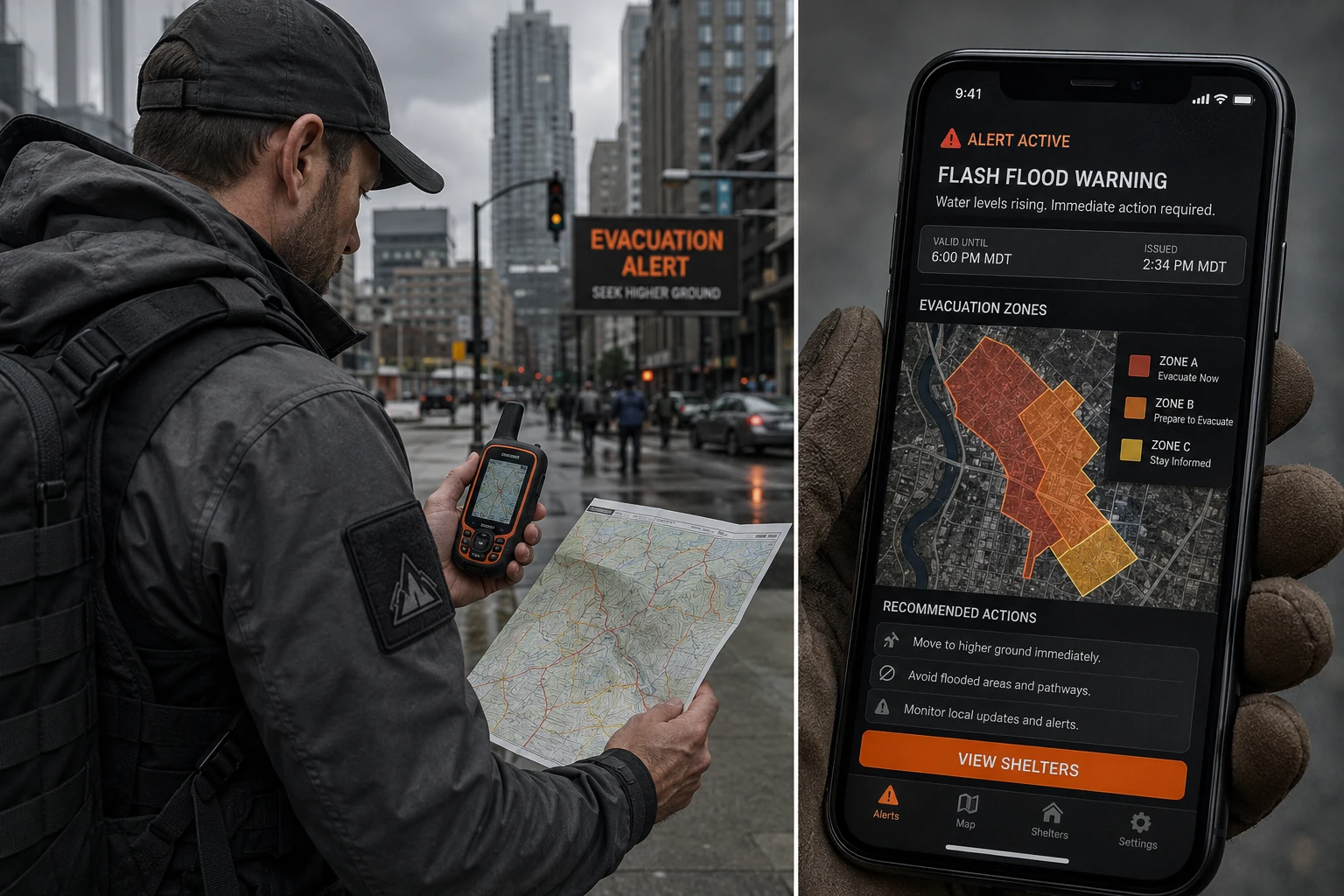
- FEMA’s IPAWS (Integrated Public Alert & Warning System): Sends wireless emergency alerts directly to phones in affected areas. No app required.
- Wireless Emergency Alerts (WEA): Built into all modern smartphones. Ensure yours is enabled.
- Google Crisis Maps / Google SOS Alerts: Displays real-time road closures, shelter locations, and hazard boundaries during declared emergencies.
- Waze: Crowdsourced traffic data can identify blocked routes faster than official sources during the early hours of an evacuation.
- GasBuddy: Helps locate open fuel stations along your route.
- County GIS portals: Most U.S. counties publish online maps showing flood zones, evacuation zones, and shelter locations — often more detailed than state-level resources.
- Offline navigation apps (Maps.me, Gaia GPS): Download your region before an emergency so navigation works without cell service.
Critical caveat: Cell networks become severely congested or fail entirely during mass evacuations. Any technology that requires a live data connection should be treated as a bonus, not a primary tool. This is why learning navigation without GPS is a skill worth developing now.
Are There Free Resources to Help Map Your Own Evacuation Strategy?
Yes — and they’re more detailed than most people realize. Building a solid urban evacuation route plan costs nothing if you know where to look.
Free planning resources:
- FEMA’s Ready.gov: Downloadable evacuation planning templates, zone lookup tools, and household planning guides.
- FEMA Flood Map Service Center (msc.fema.gov): Search your address to see flood risk and zone designation.
- Local emergency management office website: Most counties publish their official evacuation zone maps, shelter locations, and contraflow plans online.
- National Weather Service: Real-time storm tracking and evacuation guidance during weather emergencies.
- American Red Cross Safe and Well: A registry to let family members know you’ve evacuated safely.
- Google Maps (offline mode): Download your city and surrounding region for offline navigation.
The Ultimate Family Emergency Plan Template from Preppers HQ is another free resource that integrates evacuation planning with broader household preparedness.
What Happens If Main Evacuation Routes Get Blocked?
When primary routes fail — and in serious emergencies, they often do — the response is to immediately shift to your pre-planned secondary route without hesitation. The worst outcome is improvising a new route under stress with no prior knowledge of the area.
Blocked route protocol:
- Don’t wait in traffic hoping it clears. In a fast-moving emergency, sitting still is dangerous.
- Switch to your secondary route immediately. This is why you planned it.
- If secondary is also blocked, activate your on-foot contingency. Know which direction leads to safety and how far you can realistically walk.
- Use side streets and alleys to bypass gridlock — but only if you’ve mapped them in advance. Unfamiliar urban terrain at night or in smoke is disorienting.
- Shelter in place temporarily if all routes are compromised and the hazard isn’t immediately life-threatening. A well-stocked home position beats a dangerous road.
Edge case: In some scenarios (major earthquake, infrastructure collapse), vehicles become useless entirely. Every urban evacuation plan should include a realistic on-foot option with a designated meeting point at least 2–5 miles from home.
How Do People With Disabilities Create Effective Urban Evacuation Plans?
People with mobility limitations, sensory impairments, or chronic medical conditions face unique challenges during urban evacuations that standard planning guides consistently underserve. Effective planning for this group requires earlier action, more detailed logistics, and registered support networks.
Key steps for disability-inclusive planning:
- Register with your local emergency management office. Many counties maintain Special Needs Registries that flag addresses for priority evacuation assistance.
- Identify personal assistants or neighbors who can help with physical evacuation before an emergency occurs — not during one.
- Plan for medical equipment: Oxygen concentrators, dialysis, and powered wheelchairs all require power. Know which shelters have medical support capacity.
- Request accessible transportation through your county’s emergency management office in advance. Don’t assume it will be available on the day.
- Map accessible routes: Not all evacuation paths are wheelchair-accessible. Identify which roads and sidewalks remain passable for mobility devices.
- Carry a medical information card with diagnoses, medications, allergies, and emergency contacts in a waterproof pouch.
The 4-Layer Disaster Plan framework includes accommodation for household members with special needs and is worth reviewing as a structural foundation.
What Emergency Services Coordinate Urban Evacuation Efforts?
Urban evacuations are coordinated through a multi-agency system, typically led by the local Emergency Management Agency (EMA) or Office of Emergency Management (OEM), with support from state agencies, FEMA, and first responders.
Key agencies and their roles:
- Local Emergency Management Agency: Issues evacuation orders, designates zones, coordinates shelters, and manages contraflow.
- Law enforcement (police/sheriff): Controls traffic flow, enforces evacuation orders, and secures evacuated areas.
- Fire departments: Handle rescue operations, hazmat containment, and search-and-rescue in blocked zones.
- National Guard: Activated for large-scale events to support traffic management, shelter operations, and supply distribution.
- FEMA: Provides federal resources and coordinates across state lines for multi-state events.
- American Red Cross: Operates emergency shelters and provides food, water, and basic medical support.
- 211 hotline: A free, 24/7 service that connects people to local shelter information, transportation assistance, and special needs support during declared emergencies.
What this means for your plan: Don’t assume emergency services will reach you quickly. In a mass evacuation, responders are stretched thin. Your plan should assume you’re self-sufficient for the first 72 hours minimum.
Frequently Asked Questions
How many evacuation routes should I plan?
Plan a minimum of three routes: one primary, one secondary, and one on-foot option. Each should lead to a different pre-identified destination (a family member’s home, a shelter, or a rally point outside the city).
Should I evacuate by car or on foot?
Default to your vehicle when roads are passable — it’s faster and carries more supplies. Switch to on-foot only when roads are completely blocked, your vehicle is disabled, or the hazard makes driving more dangerous than walking.
How do I find out my evacuation zone?
Search “[your city or county] evacuation zone map” or visit your local emergency management office website. Most jurisdictions have an address lookup tool. Do this now, not during an emergency.
What’s the best time to leave during an evacuation order?
Leave as early as possible — ideally before an official order is issued if you’re in a high-risk zone. Every hour of delay after an order significantly increases congestion and reduces route options.
Can I use Waze or Google Maps during an evacuation?
Yes, but treat them as supplements. Cell networks frequently fail during mass evacuations. Always have downloaded offline maps and printed paper maps as backups.
What if my family is separated when the emergency hits?
Establish a pre-agreed out-of-area contact person and two physical meeting points (one near home, one outside the city). Text messages often get through when voice calls can’t. For a complete system, see the Emergency Communication Plan guide.
How often should I update my evacuation plan?
Review and update your plan at least twice a year — once before hurricane season (June) and once before winter. Update it immediately after any major change: new family members, a move, a new vehicle, or changes to local infrastructure.
Do I need a different plan for each type of disaster?
You need one core plan with scenario-specific adjustments. The route, timing, and destination may change based on the hazard type, but the underlying structure (bag packed, documents ready, family communication established) stays the same.
What’s the most important thing to do right now?
Look up your evacuation zone, identify three routes out of your city on a paper map, and make sure everyone in your household knows where to go and how to reach each other. That’s the foundation everything else builds on.
Are pets allowed in evacuation shelters?
Most general population shelters do not accept pets. Pre-identify pet-friendly hotels, veterinary offices offering boarding during emergencies, or friends/family outside the evacuation zone who can take your animals.
What if I can’t afford a bug out bag?
Start with what you have. A backpack with water, a few days of non-perishable food, a flashlight, a first aid kit, and your important documents is a functional starting point. Build from there over time.
How do I practice my evacuation plan?
Run a timed drill at least once a year. Set a timer, grab your bags, load the vehicle, and drive your primary route to your first destination. Note what slowed you down and fix it.
Conclusion: Build the Plan Before You Need It
The gap between people who make it out safely and people who don’t usually comes down to one thing: preparation done in advance. An urban evacuation route planning guide is only useful if the plan actually exists before the emergency starts.
Actionable next steps to take this week:
- Look up your evacuation zone on your county’s emergency management website today.
- Print a paper map of your city and mark three routes out — primary, secondary, and on-foot.
- Check your fuel level and commit to keeping it above half during any elevated threat period.
- Confirm your family communication plan — out-of-area contact, two meeting points, text as primary method.
- Audit your bug out bag and replace anything expired or missing.
- Register with your county’s Special Needs Registry if any household member has a disability or medical dependency.
- Run one timed practice drill within the next 30 days.
Preparedness isn’t about fear. It’s about the confidence that comes from knowing exactly what you’ll do when everyone else is figuring it out on the fly. The city doesn’t owe you a clear exit. Build your own.
For deeper preparation, explore the Ultimate Evacuation Plan Guide and the Bug Out Plan for Survival Preparedness to build the full system around your urban evacuation strategy.
Products, Tools, and Resources Worth Knowing
These are practical tools that support a real urban evacuation route planning guide — not affiliate filler, but gear that experienced preppers actually use:
- Garmin inReach Mini 2: A satellite communicator that works when cell networks are down. Sends your location and two-way messages via satellite. Genuinely useful when phones fail.
- Rand McNally Road Atlas (current year edition): Old-school, but paper maps don’t need batteries or a signal. Get one for your vehicle and one for your bag.
- Sawyer Squeeze Water Filter: Lightweight, reliable, and filters up to 100,000 gallons. If your evacuation route passes near any water source, this matters.
- Midland ER310 Emergency Crank Radio: Receives NOAA weather alerts and emergency broadcasts without grid power. Charges via hand crank, solar, or USB.
- Anker PowerCore 26800 Portable Charger: Keeps phones, radios, and GPS devices running for multiple days between charges.
- Laminated city/county map set: Many local print shops can laminate your downloaded county GIS maps for a few dollars. Waterproof and durable.
- FEMA’s Ready.gov household planning templates: Free, downloadable, and genuinely useful for building the document side of your plan.
For a complete gear framework, the Complete Bug Out Bag Guide walks through every category with specific recommendations and budget options.