

Affiliate Disclosure: Hey there! As an Amazon Associate, some links on this page may be affiliate links which means that, if you choose to make a purchase, I may earn a commission at no extra cost to you. I greatly appreciate your support!
There is a specific kind of disorientation that has no historical precedent.
It happens when a hiker pulls out their phone to check their location and finds a dead battery. When a backpacker discovers their GPS device has lost signal in a canyon. When a driver’s navigation app reroutes them into an unfamiliar neighborhood and then, inexplicably, goes silent.
For most of human history, people navigated. They read the land, the sky, the water, and the wind. They built mental maps of their environments and moved through the world with a confidence that had nothing to do with satellites.
That confidence is recoverable. This guide is how you recover it.
14 Essential Survival Skills Every Prepper Must Know
Navigation without GPS is not a single skill. It’s a skill stack — a layered system of complementary competencies that work together to answer the fundamental navigation question: where am I, where am I going, and how do I get there?
Most beginners approach GPS-free navigation as if it’s one thing. They buy a compass, discover it’s more complicated than they expected, and conclude that navigation without GPS is too difficult for non-experts. This conclusion is wrong — but it’s the predictable result of treating a skill stack as if it were a single skill.
The three categories of GPS-free navigation are distinct, and understanding how they relate to each other changes everything:
Map-based navigation uses topographic maps to understand terrain, identify your position, and plan routes. This is the foundation. Everything else builds on it.
Instrument navigation uses a compass to determine direction, take bearings, and navigate between points. It requires map reading to be meaningful.
Natural navigation uses environmental cues — the sun, moon, stars, vegetation, terrain, and weather — to determine direction without any instruments. It’s the backup system when everything else fails.
These three categories are not alternatives. They are layers of a system. A navigator who can use all three is significantly more capable — and significantly safer — than one who relies on any single method.
Key Takeaways:
– Navigation without GPS relies on three complementary skill sets: map reading, compass use, and natural navigation; mastering all provides greater safety and confidence.
– Start by learning to read topographic maps and understand contour lines, then progress to compass skills, terrain association, and finally natural navigation methods.
– Magnetic declination is crucial for accurate compass use; always adjust bearings to account for the difference between magnetic north and true north.
– Practice is essential: consistent daily exercises over 30 days can build foundational navigation competence usable in most environments.
– Use terrain features like handrails, catching features, and attack points to improve route-finding accuracy and confirm your position continuously.
The Skill Stack — What to Learn and In What Order
 The correct learning sequence follows a specific logic:
- Map reading first — because understanding terrain on paper is the foundation of understanding terrain in reality
- Compass use second — because compass navigation requires map reading to be meaningful
- Terrain association third — because connecting map features to real terrain features is what makes navigation reliable
- Natural navigation fourth — because natural navigation methods are the backup system when instruments fail
This sequence isn’t arbitrary. Each skill builds on the previous one. A beginner who tries to learn compass navigation before map reading will struggle. A beginner who tries to learn terrain association before compass navigation will lack the directional reference needed for precision.
What You Can Realistically Achieve in 30 Days
Before beginning, honest expectations matter.
What 30 days of regular practice produce:
- Reading a topographic map and identifying major terrain features
- Orienting a map to terrain using both compass and terrain features
- Taking a bearing from a map and following it in the field
- Finding your approximate position using triangulation
- Determining direction using the shadow stick method and Polaris
- Navigating a familiar route without GPS
What takes longer:
- Reliable navigation in complex, featureless terrain
- Accurate dead reckoning over long distances
- Confident navigation in poor visibility
- Mastery of stellar navigation beyond Polaris
The short version: Navigation without GPS uses three complementary skill categories — map-based navigation, instrument navigation (compass), and natural navigation. The correct learning sequence is map reading first, then compass use, then terrain association, then natural navigation. Basic competence is achievable in 30 days of regular practice.
Part One: Map Reading — The Foundation of Everything
Topographic Maps — What Every Symbol and Line Actually Means
 A topographic map is fundamentally different from every other type of map. A road map shows roads. A satellite image shows surface appearance. A topographic map shows the three-dimensional shape of the land — its elevation, its contours, its features — represented on a two-dimensional surface.
This is the map that navigation without GPS requires. Not because other maps are useless, but because topographic maps contain the information that allows you to understand terrain before you encounter it, identify your position by matching what you see to what the map shows, and plan routes that account for the actual shape of the land.
What a topographic map shows:
- Elevation and terrain shape (through contour lines)
- Water features (rivers, streams, lakes, ponds, marshes)
- Vegetation (forests, clearings, scrub)
- Human features (roads, trails, buildings, fences)
- Magnetic north and true north (through the declination diagram)
- Scale (the relationship between map distance and real distance)
Contour Lines — The Language of Terrain on Paper
Contour lines are the defining feature of topographic maps and the concept that beginners find most challenging. Once understood, they transform a flat piece of paper into a three-dimensional landscape.
The fundamental rule: Every point on a contour line is at the same elevation. A contour line connects all points at a specific height above sea level.
Contour interval: The elevation difference between adjacent contour lines. This is printed in the map legend — typically 20, 40, or 80 feet (or 10, 20, or 40 meters on metric maps). If the contour interval is 40 feet, every contour line represents a 40-foot elevation change.
Index contours: Every fifth contour line is printed darker and labeled with its elevation. These make it easier to read elevation quickly.
Reading contour lines — the key principles:
Closely spaced contour lines = steep terrain. When contour lines are packed tightly together, the terrain rises or falls rapidly. Lines that touch or overlap indicate a cliff.
Widely spaced contour lines = gentle terrain. When contour lines are far apart, the terrain slopes gradually.
V-shaped contours pointing uphill = valley or drainage. When contour lines form a V shape with the point of the V pointing toward higher elevation, they indicate a valley, drainage, or stream channel. Water flows in the direction the V points.
V-shaped contours pointing downhill = ridge. When contour lines form a V shape with the point of the V pointing toward a lower elevation, they indicate a ridge or spur.
Closed circles = hilltop or depression. A closed contour line indicates either a hilltop (if the enclosed area is higher than the surrounding terrain) or a depression (if lower). Depressions are marked with tick marks on the inside of the closed contour.
Military navigation training identifies five major terrain features that every navigator must be able to identify on a topographic map and in the field. These five features form the vocabulary of terrain association.
- Hill (Summit)
A hill is a point of high ground that rises above the surrounding terrain.
On the map: Concentric closed contour lines, with the innermost being the highest. In the field: Ground that rises in all directions from a central high point.
- Valley
A valley is a low area between hills or mountains, typically containing a stream or river.
On the map: U-shaped or V-shaped contour lines with the opening pointing downhill. The V-shapes point uphill (toward the head of the valley). In the field: Low ground between higher terrain, often with a water feature.
- Ridge
A ridge is a line of high ground with lower ground on both sides.
On the map: U-shaped or V-shaped contour lines with the opening pointing uphill. The V-shapes point downhill (away from the ridge). In the field: Elevated ground that falls away on both sides.
- Saddle
A saddle is a low point between two higher areas — the low point on a ridge between two summits. Also called a pass or col.
On the map: An hourglass shape formed by two sets of closed contour lines connected by a narrow area of lower elevation. In the field: A dip or low point on a ridge, with higher ground on both sides and lower ground in the other two directions.
- Depression
A depression is a low point surrounded by higher ground on all sides.
On the map: Closed contour lines with tick marks on the inside (pointing toward the lowest point). In the field: Ground that slopes downward in all directions from the rim.
Map Scale — How to Calculate Real Distances
Map scale is the ratio between distance on the map and distance in reality. Understanding scale allows you to estimate how far you need to travel and how long it will take.
Common topographic map scales:
- 1:24,000 (USGS 7.5-minute series): 1 inch on the map = 2,000 feet in reality. The most detailed standard topographic map scale in the United States.
- 1:50,000 (common military and international scale): 1 cm on the map = 500 meters in reality.
- 1:100,000: 1 cm on the map = 1 kilometer in reality.
- 1:250,000: 1 cm on the map = 2.5 kilometers in reality. Used for large-area planning.
How to measure map distance:
- Use a piece of string or the edge of your compass baseplate to measure the distance along your intended route on the map
- Compare that measurement to the map’s scale bar (printed in the legend)
- The result is the straight-line distance — add 10 to 30% for terrain (hills, curves in the trail) to estimate the actual travel distance
Naismith’s Rule for estimating travel time:
Allow 1 hour for every 5 kilometers (3 miles) of horizontal distance, plus 1 hour for every 600 meters (2,000 feet) of ascent. Adjust based on your fitness level, terrain difficulty, and pack weight.
Grid Systems — UTM and Latitude/Longitude
Two grid systems are commonly used on topographic maps:
Latitude and Longitude: The global coordinate system that divides the Earth into degrees of latitude (north-south) and longitude (east-west). Coordinates are expressed as degrees, minutes, and seconds (DMS) or as decimal degrees (DD). For example: 40°26’46″N, 79°58’56″W (DMS) or 40.4461°N, 79.9822°W (DD).
UTM (Universal Transverse Mercator): A metric grid system that divides the world into 60 zones, each 6° of longitude wide. Within each zone, locations are described by easting (distance east from the zone’s central meridian) and northing (distance north from the equator). UTM coordinates are easier to use for measuring distances on a map because they’re in meters — a difference of 1,000 in easting or northing equals exactly 1 kilometer.
For beginners, latitude and longitude are more universally understood and easier to communicate. UTM is more practical for precise field navigation. Learn both.
How to Orient a Map to Terrain — The Skill That Makes Everything Work
Map orientation is the process of aligning your map so that north on the map corresponds to north in the real world, and the features on the map correspond to the features you can see around you.
An oriented map is the foundation of all terrain association. Without it, the map is just a picture. With it, the map becomes a real-time representation of your environment.
Method 1: Orienting by terrain features (no compass required)
- Identify two or more terrain features you can see in the real world (a hilltop, a valley, a lake, a road)
- Find those same features on the map
- Rotate the map until the features on the map align with the features in the real world
- The map is now oriented — north on the map points toward real-world north
This method works well in terrain with distinctive, identifiable features. It becomes difficult in featureless terrain or poor visibility.
Method 2: Orienting by compass
- Set your compass to 0° (north)
- Place the compass on the map with the direction-of-travel arrow pointing toward the top of the map (map north)
- Rotate the map and compass together until the compass needle aligns with the orienting arrow (red end north)
- The map is now oriented to magnetic north
Common map orientation mistakes:
- Orienting the map to the direction you’re traveling rather than to the north
- Forgetting to account for magnetic declination
- Orienting the map once and not re-orienting as you move
- Trying to navigate from an unoriented map
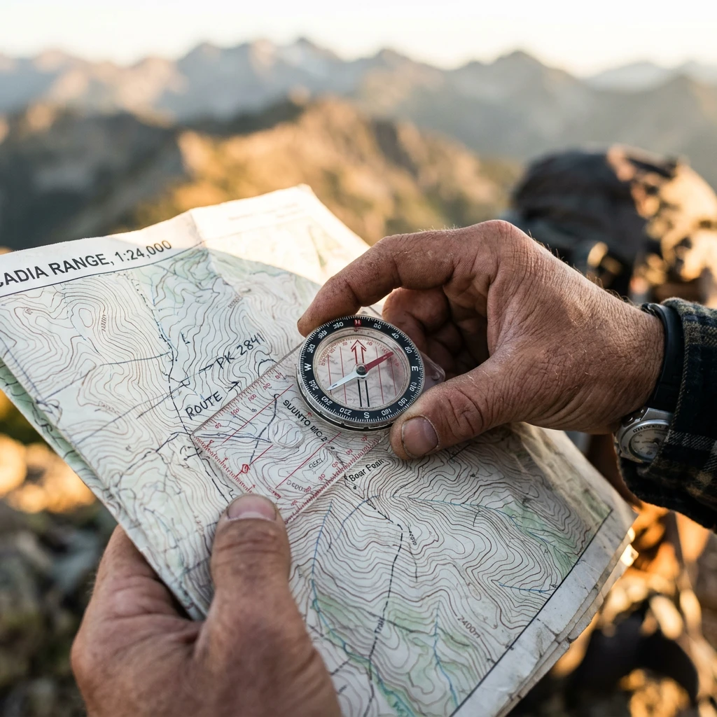
Choosing Your First Compass — What Actually Matters

Not all compasses are created equal, and the wrong compass can make learning navigation significantly harder than it needs to be.
Types of compasses:
Baseplate compass (also called orienteering compass): The standard recommendation for beginners and experienced navigators alike. A transparent rectangular base with a rotating compass housing mounted on it. The most versatile and widely used compass type for land navigation.
Lensatic compass (military compass): A folding compass with a sighting lens for precise bearing measurement. More accurate for taking bearings to distant objects, but more complex to use and less practical for map work. Not recommended as a first compass.
Button compass: A small, inexpensive compass with no baseplate or rotating housing. Useful as a backup but not suitable for serious navigation.
For beginners, the recommendation is clear: a quality baseplate compass from a reputable manufacturer. The Suunto A-10, Silva Ranger, or Brunton TruArc 3 are consistently recommended. Expect to spend $20 to $50 for a reliable beginner compass.
The Anatomy of a Baseplate Compass — Every Part Explained
Baseplate: The transparent rectangular base. Contains the direction-of-travel arrow, the ruler (for measuring map distances), and the index line.
Direction-of-travel arrow: The arrow printed on the baseplate that points in the direction you want to travel. When taking a bearing, this arrow points toward your destination.
Compass housing (bezel): The rotating circular housing that contains the compass needle and the orienting arrow. The outside of the housing is marked with degrees from 0° to 360°.
Compass needle: The magnetized needle inside the housing that always points toward magnetic north. The red end points north; the white or black end points south.
Orienting arrow: The arrow printed on the bottom of the compass housing (inside the housing). When the compass needle is aligned with the orienting arrow (red end north), the compass is oriented to magnetic north.
Orienting lines: Parallel lines printed on the bottom of the compass housing. Used to align the compass with the north-south grid lines on a map.
Index line: The line on the baseplate where you read the bearing. Located at the base of the direction-of-travel arrow.
Magnetic Declination — The Concept That Trips Up Every Beginner
Magnetic declination is the angular difference between magnetic north (where your compass needle points) and true north (the direction toward the geographic North Pole). It is the single most important concept in compass navigation — and the one that most beginners skip, leading to navigational errors that compound over distance.
Why magnetic declination matters:
Topographic maps are oriented to true north. Compass needles point to magnetic north. In most locations, these are not in the same direction. The difference — magnetic declination — varies by location and changes slowly over time.
In the continental United States, magnetic declination ranges from approximately 20° west (in the Pacific Northwest) to 20° east (in New England). In Europe, declination ranges from approximately 5° west (in western Europe) to 10° east (in eastern Europe).
The practical impact:
If you’re navigating in an area with 15° east declination and you don’t account for it, every bearing you take will be 15° off. Over a 1-kilometer route, a 15° error produces a lateral displacement of approximately 268 meters — enough to miss a trail junction, a campsite, or a rescue point entirely.
How to find your local magnetic declination:
- Check the declination diagram printed on your topographic map (note the date — declination changes over time)
- Use the NOAA Magnetic Declination Calculator (ngdc.noaa.gov) for current values
How to account for magnetic declination:
Method 1 — Adjust the compass: Some compasses have an adjustable declination scale. Set the declination on the compass, and it automatically compensates.
Method 2 — Adjust the bearing mathematically:
- East declination: Subtract the declination from your map bearing to get your compass bearing
- West declination: Add the declination to your map bearing to get your compass bearing
The mnemonic: “East is least, west is best” — east declination means you subtract from the map bearing; west declination means you add.
The Three Core Compass Skills Every Beginner Must Master
Skill 1: Taking a Bearing from a Map to a Destination
A bearing is a direction expressed in degrees (0° to 360°). Taking a bearing from a map tells you the direction you need to travel to reach your destination.
Step-by-step process:
- Place your compass on the map with one long edge of the baseplate connecting your current position to your destination
- Make sure the direction-of-travel arrow is pointing toward your destination (not away from it)
- Rotate the compass housing until the orienting lines are parallel to the north-south grid lines on the map, with the orienting arrow pointing toward the map north
- Read the bearing at the index line — this is your map bearing
- Adjust for magnetic declination
- The result is your compass bearing — the direction you need to travel
Skill 2: Following a Bearing in the Field
Once you have a bearing, you need to follow it accurately.
Step-by-step process:
- Hold the compass level in front of you with the direction-of-travel arrow pointing away from you
- Rotate your body (not the compass housing) until the compass needle aligns with the orienting arrow (red end north)
- The direction-of-travel arrow now points in the direction of your bearing
- Look up and identify a landmark in that direction — a tree, a rock, a hilltop
- Walk to that landmark, then repeat the process
Why landmark navigation matters: Walking while looking at a compass is slow, inaccurate, and dangerous. The correct technique is to take a bearing, identify a landmark in that direction, put the compass away, walk to the landmark, and repeat.
Skill 3: Triangulation — Finding Your Exact Position
Triangulation (also called resection) is the process of determining your exact position on a map by taking bearings to two or more known landmarks.
Step-by-step process:
- Identify two or three landmarks that you can see in the real world and find on the map
- Take a bearing to the first landmark using your compass
- Convert the compass bearing to a map bearing (accounting for declination)
- On the map, draw a line from the first landmark in the direction of the back-bearing (the bearing plus or minus 180°) — your position is somewhere on this line
- Repeat for the second landmark
- Your position is where the two lines intersect
With three landmarks, the three lines should form a small triangle (called a “cocked hat”) — your position is within that triangle. The smaller the triangle, the more accurate your position fix.
Dead reckoning is the process of calculating your current position based on a known starting position, your direction of travel, your speed, and elapsed time. It is the navigation method of last resort — used when landmarks are unavailable or invisible.
The basic formula: Distance = Speed × Time
Pace counting — measuring distance without technology:
A pace is two steps (left-right = one pace). Pace counting measures distance by counting the number of paces you take.
Calibrating your pace count:
- Measure a known distance — 100 meters is standard
- Walk that distance at your normal hiking pace, counting every time your left foot hits the ground
- Record the number — this is your pace count per 100 meters
- Most adults have a pace count of 60 to 70 per 100 meters on flat terrain
Adjusting for terrain:
- Uphill: pace count increases (you take shorter steps)
- Downhill: pace count decreases (you take longer steps)
- Dense vegetation: pace count increases
- Heavy pack: pace count increases
Practical dead reckoning:
- Note your starting position on the map
- Take a compass bearing to your destination
- Walk on that bearing, counting paces
- Every 100 meters (based on your pace count), mark your progress on the map
- Adjust for terrain changes
Dead reckoning errors accumulate over distance. A small error in bearing or pace count becomes a significant positional error over several kilometers. Dead reckoning is most useful for short distances (under 1 kilometer) or as a supplement to terrain association.
 Natural navigation is the art of determining direction using environmental cues — the sun, moon, stars, vegetation, terrain, and weather. It is the oldest human navigation system, predating compasses by millennia, and it remains the most reliable backup when instruments fail.
The sun is the most powerful and reliable natural navigation tool available during daylight hours.
The sun’s arc:
In the Northern Hemisphere, the sun rises in the east, reaches its highest point in the south at solar noon, and sets in the west. In the Southern Hemisphere, the sun reaches its highest point in the north at solar noon.
The shadow stick method uses the movement of a shadow to determine the east-west line, from which north and south can be derived.
Step-by-step process:
- Find a flat, level area with direct sunlight
- Push a straight stick (approximately 1 meter long) vertically into the ground
- Mark the tip of the shadow with a stone, stick, or scratch in the ground — this is your first mark (West mark)
- Wait 15 to 20 minutes
- Mark the new position of the shadow tip — this is your second mark (East mark)
- Draw a line between the two marks — this line runs approximately east-west (first mark is west, second mark is east)
- Draw a line perpendicular to the east-west line — this runs north-south
Why the first mark is west: The sun moves from east to west across the sky. As it moves, shadows move in the opposite direction — from west to east. The first shadow tip is therefore west of the second.
The watch method (Northern Hemisphere):
If you have an analog watch set to local time (not daylight saving time):
- Hold the watch horizontally
- Point the hour hand toward the sun
- The south direction is halfway between the hour hand and the 12 o’clock position
Example: If it’s 4:00 PM, the hour hand points toward the sun. Halfway between 4 and 12 (going the short way) is 2. The 2 o’clock position on the watch points south.
In the Southern Hemisphere: Point the 12 o’clock position toward the sun. North is halfway between the 12 and the hour hand.
The night sky provides the most precise natural navigation reference available — but only when the sky is clear.
Polaris is located almost exactly above the Earth’s geographic North Pole. It appears to remain stationary in the sky while all other stars rotate around it. Finding Polaris gives you true north within approximately 1 degree — more accurate than most compasses.
Method 1 — Using the Big Dipper (Ursa Major):
- Locate the Big Dipper — a group of seven stars in the shape of a ladle or dipper
- Find the two stars that form the outer edge of the dipper’s cup (the “pointer stars”) — these are Dubhe and Merak
- Draw an imaginary line from Merak through Dubhe and extend it approximately 5 times the distance between them
- The moderately bright star at that location is Polaris
Method 2 — Using Cassiopeia:
Cassiopeia is a W-shaped constellation on the opposite side of Polaris from the Big Dipper. When the Big Dipper is low on the horizon, Cassiopeia is high, and vice versa.
- Locate Cassiopeia — the W shape is distinctive
- Find the middle point of the W
- Draw an imaginary line from the middle of the W toward the open side of the W
- Extend that line approximately twice the height of the W
- Polaris is at the end of that line
Once you’ve found Polaris, you’re looking at true north. Face Polaris and you’re facing north. East is to your right, west is to your left, south is behind you.
In the Southern Hemisphere, there is no bright star near the south celestial pole. The Southern Cross (Crux) is used instead.
- Locate the Southern Cross — four bright stars forming a cross shape, with a fifth star nearby
- Identify the long axis of the cross (the two stars farthest apart)
- Extend the long axis of the cross approximately 4.5 times its length in the direction it points
- That point in the sky is approximately the south celestial pole
- Drop a vertical line from that point to the horizon — that point on the horizon is south
When the moon is in a crescent phase, draw an imaginary line connecting the two tips of the crescent (the “horns”) and extend it to the horizon. In the Northern Hemisphere, this point on the horizon is approximately south. In the Southern Hemisphere, it is approximately north. This method is approximate — accurate to within 20 to 30 degrees — so use it as a rough directional check, not a precise bearing.
The environment itself contains directional information that experienced navigators learn to read automatically.
Water flows downhill. Following water downstream leads to lower elevations, larger water bodies, and eventually human habitation. This is one of the most reliable navigation principles available — it works in any terrain where water is present.
Vegetation patterns as directional indicators:
What actually works:
- Wind-shaped trees: In areas with consistent prevailing winds, trees develop asymmetrical growth — branches grow more densely on the leeward (sheltered) side. If you know the prevailing wind direction for your area, wind-shaped trees can indicate direction.
- Snow melt patterns: In the Northern Hemisphere, south-facing slopes receive more direct sunlight and snow melts faster on them. In spring, south-facing slopes are often snow-free while north-facing slopes retain snow.
- Vegetation density: In the Northern Hemisphere, south-facing slopes are typically drier and have different vegetation than north-facing slopes. This difference is most pronounced in arid environments.
What doesn’t reliably work:
- “Moss grows on the north side of trees”: This is one of the most persistent navigation myths. Moss grows where moisture is retained, which is often the north side of trees in the Northern Hemisphere, but not always. Moss growth is influenced by local moisture, shade, and microclimate. Do not rely on moss for navigation.
20 Essential Bushcraft Skills for Beginners — Ranked by Priority and Practicality
Part Four: Terrain Association — The Skill That Connects Everything
 Terrain association is the process of continuously matching the terrain features you see in the real world to the terrain features shown on your map. It is not a single technique — it is a continuous, dynamic process of position confirmation that runs in the background of all navigation.
A navigator using terrain association doesn’t just check their position occasionally. They maintain a continuous mental model of their position by constantly comparing what they see to what the map shows. Every hilltop, every valley, every stream crossing, every change in vegetation is a data point that confirms or challenges their position estimate.
Terrain association is more reliable than compass-only navigation because it uses multiple data sources simultaneously. A compass bearing can be wrong — due to declination error, local magnetic anomalies, or simple mistakes. Terrain features don’t lie.
Handrails, Catching Features, and Attack Points — The Terrain Association Vocabulary
Handrails:
A handrail is a linear terrain feature that runs roughly parallel to your intended route and can be used to guide navigation. Handrails keep you on course without requiring constant compass checks.
Examples of handrails:
- A river or stream running parallel to your route
- A road or trail running parallel to your route
- A ridgeline running parallel to your route
- A fence or power line running parallel to your route
How to use a handrail: Identify a handrail on your map that runs parallel to your intended route. Navigate to the handrail, then follow it. When the handrail ends or diverges from your route, use a compass bearing to navigate to your destination.
Catching features:
A catching feature is a terrain feature that lies beyond your destination — a feature that “catches” you if you overshoot. It tells you that you’ve gone too far.
Examples of catching features:
- A river that crosses your route beyond your destination
- A road that crosses your route beyond your destination
- A ridgeline that crosses your route beyond your destination
How to use a catching feature: Identify a catching feature on your map beyond your destination. If you reach the catching feature without finding your destination, you know you’ve overshot and need to backtrack.
Attack points:
An attack point is a large, easily identifiable terrain feature near your destination from which you make your final approach. It’s the last “known position” before navigating to a smaller, harder-to-find destination.
Example: You’re navigating to a small spring in a forest. The spring is difficult to find directly. But there’s a distinctive hilltop 300 meters from the spring. You navigate to the hilltop (the attack point), then take a precise compass bearing to the spring for the final 300 meters.
Why attack points matter: Navigating directly to a small destination over a long distance accumulates errors. Navigating to a large, obvious attack point and then making a short, precise final approach is significantly more reliable.
Scenario: You’re hiking in a forested area. Your starting position is a trail junction marked on your map. Your destination is a lake 3 kilometers to the northeast.
Step 1: Study the map before moving
Before leaving the trail junction, study the map carefully. Identify:
- The general direction to the lake (northeast)
- The terrain features you’ll encounter along the way (a stream crossing at 1 km, a ridgeline at 1.5 km, a descent into a valley at 2 km, the lake at 3 km)
- A handrail (the stream runs roughly northeast for the first kilometer)
- A catching feature (a road runs east-west beyond the lake)
- An attack point (the ridgeline at 1.5 km is distinctive and easy to identify)
Step 2: Orient your map
Orient your map using your compass, accounting for magnetic declination.
Step 3: Take an initial bearing
Take a compass bearing from your current position to the lake. The bearing is approximately 045° (northeast). Adjust for magnetic declination.
Step 4: Navigate using the handrail
Follow the stream northeast for the first kilometer. The stream is your handrail — it keeps you on course without requiring constant compass checks.
Step 5: Confirm position at the stream crossing
When you reach the stream crossing, confirm your position on the map. The crossing should match what the map shows. If it does, you’re on track.
Step 6: Navigate to the attack point
From the stream crossing, take a bearing to the ridgeline (your attack point). Navigate to the ridgeline using compass and terrain association.
Step 7: Confirm position at the attack point
From the ridgeline, you should be able to see the valley below and confirm your position. The lake should be approximately 1.5 kilometers ahead.
Step 8: Final approach
From the ridgeline, take a precise bearing to the lake. Navigate down into the valley using the bearing and terrain association. The road beyond the lake is your catching feature — if you reach it, you’ve overshot.
 Forest navigation presents specific challenges: limited visibility, few distant landmarks, and the disorienting effect of dense vegetation.
Key strategies:
Use the compass more, terrain less. In dense forest, you often can’t see the terrain features that terrain association relies on. Compass navigation becomes more important.
Use handrails aggressively. Streams, ridgelines, and trails are invaluable in forest navigation because they’re identifiable even in dense vegetation.
Maintain pace count. Without visible landmarks, pace counting is the primary method for tracking distance.
The “aiming off” technique:
When navigating to a point on a linear feature (a trail junction, a stream crossing), deliberately aim slightly to one side of your destination. When you reach the linear feature, you’ll know which direction to turn to find your destination. This eliminates the uncertainty of not knowing which way to turn when you reach the feature.
Mountain navigation is the most demanding form of GPS-free navigation because of the combination of complex terrain, rapidly changing weather, and the consequences of navigational errors.
Key strategies:
Plan your route in detail before leaving. Study the map carefully and identify every terrain feature you’ll encounter. Know your escape routes.
Use ridgelines for navigation. Ridgelines provide visibility, easier travel, and clear terrain association. Navigate on ridgelines when possible.
Account for the weather. Mountain weather changes rapidly. Clouds can eliminate visibility and make terrain association impossible. Always have a compass bearing ready for your escape route.
The summit as an attack point:
In mountain navigation, summits are often the most reliable attack points. They’re large, distinctive, and identifiable from a distance. Navigate to a summit, confirm your position, then navigate to your destination from the summit.
Desert navigation presents the opposite challenge from forest navigation: too much visibility, too few distinctive features.
Key strategies:
Use compass navigation as your primary method. In featureless desert terrain, there are often no landmarks for terrain association. Compass navigation with pace counting is the primary navigation method.
Navigate at dawn and dusk. The low angle of the sun at dawn and dusk creates shadows that reveal subtle terrain features invisible at midday. Navigation is also safer in cooler temperatures.
Solar navigation is highly reliable in desert environments. Clear skies and strong sunlight make the shadow stick method particularly accurate in desert conditions.
Urban navigation without GPS is a different skill set from wilderness navigation, but the underlying principles are the same.
Key strategies:
Use a paper map. City maps are widely available and provide the same orientation benefits as topographic maps in wilderness settings.
Use the sun for direction. Solar navigation works in cities just as well as in wilderness environments.
Learn the grid. Many cities are built on a grid system. Understanding the grid orientation (which direction the streets run) provides a constant directional reference.
Count blocks. Block counting is the urban equivalent of pace counting — it allows you to track distance without technology.
Part Six: The 30-Day Practice Plan — Building Real Competence
Knowledge without practice is not a navigation skill. It is a navigation fantasy. The gap between reading about navigation and actually being able to navigate is bridged by one thing: deliberate, progressive, scenario-based practice.
Week 1: Map Reading Fundamentals
Goal: Develop fluency in reading topographic maps.
Daily practice (20 minutes):
- Days 1–2: Obtain a topographic map of your local area. Identify all five major terrain features on the map. Find examples of each in your local area.
- Days 3–4: Practice reading contour lines. For each contour pattern you identify, predict what the terrain looks like in reality. Then visit that terrain and confirm your prediction.
- Days 5–7: Practice map orientation. Take your map to a location with visible terrain features. Orient the map using terrain features alone (no compass). Confirm your orientation by matching map features to real features.
End of Week 1 benchmark: You can identify all five major terrain features on a topographic map and orient a map to terrain using terrain features alone.
Goal: Develop functional compass navigation skills.
Daily practice (30 minutes):
- Days 8–9: Learn your compass anatomy. Practice taking bearings from your map to specific destinations. Calculate the magnetic declination for your area and practice adjusting bearings.
- Days 10–11: Practice following bearings in the field. Set a bearing to a visible landmark, follow it, and confirm you’ve arrived at the correct location. Repeat with increasingly distant landmarks.
- Days 12–14: Practice triangulation. Find two visible landmarks on your map. Take bearings to both and triangulate your position. Confirm your position using terrain features.
End of Week 2 benchmark: You can take a bearing from a map, follow it in the field, and triangulate your position using two landmarks.
Goal: Develop reliable natural navigation skills.
Daily practice (15 minutes):
- Days 15–17: Practice the shadow stick method every day. Record the direction it indicates and confirm it with your compass. Note the accuracy.
- Days 18–20: Practice finding Polaris on clear nights. Time yourself — how quickly can you find it? Practice using Polaris to determine north and confirm with your compass.
- Day 21: Practice the watch method (if you have an analog watch). Compare the result to your compass.
End of Week 3 benchmark: You can determine direction using the shadow stick method and find Polaris reliably on clear nights.
Goal: Combine all skills in real navigation scenarios.
- Days 22–24: Navigate a familiar route (a local park, a hiking trail) without GPS. Use a map, compass, and terrain association. Note where you feel confident and where you feel uncertain.
- Days 25–27: Navigate an unfamiliar route without GPS. Plan your route using the map. Use handrails, catching features, and attack points.
- Days 28–30: Complete a navigation challenge — a route with multiple waypoints, navigated entirely without GPS. Evaluate your performance honestly.
End of Week 4 benchmark: You can navigate an unfamiliar route without GPS using a map, a compass, and terrain association.
Courses and Resources Worth Investing In
Orienteering: Competitive orienteering is one of the most effective ways to develop navigation skills quickly. Orienteering events provide a structured navigation challenge with immediate feedback. Find events through your national orienteering federation.
Navigation courses:
- National Outdoor Leadership School (NOLS): Offers wilderness navigation courses that cover map reading, compass navigation, and terrain association in real wilderness environments.
- Local mountaineering clubs: Many offer navigation courses for beginners at low cost.
Navigation without GPS can be highly accurate when multiple methods are used together. Terrain association combined with compass navigation can achieve positional accuracy of 50 to 100 meters in most terrain. Dead reckoning alone is less accurate — errors of 5 to 10% of distance traveled are typical. Natural navigation methods (shadow stick, Polaris) are accurate to within a few degrees of direction. The key is using multiple methods simultaneously and cross-checking results.
Yes — and stellar navigation is actually more precise than solar navigation in many conditions. Polaris provides true north within approximately 1 degree, which is more accurate than most compass readings. The limitation is cloud cover — stellar navigation requires a clear sky. In overcast conditions at night, compass navigation and terrain association (using a headlamp to read the map) are the primary methods.
How long does it actually take to learn this?
Basic navigation competence — enough to navigate a planned route in familiar terrain without GPS — is achievable in 30 days of regular practice (20 to 30 minutes per day). This includes map reading, basic compass navigation, and terrain association. Mastery of all navigation methods, including reliable natural navigation and navigation in complex terrain, takes 6 to 12 months of regular practice.
Map reading. All other navigation skills — compass use, terrain association, natural navigation — are significantly more effective when combined with map reading. A person who can read a topographic map but has no compass can still navigate effectively using terrain association. A person who has a compass but can’t read a map has limited navigation capability.
What’s the difference between magnetic north and true north?
True north is the direction toward the geographic North Pole — the point around which the Earth rotates. Magnetic north is the direction toward the Earth’s magnetic north pole — the point toward which compass needles point. The magnetic north pole is not in the same location as the geographic North Pole, and it moves slowly over time. The angular difference between magnetic north and true north at any given location is called magnetic declination. Topographic maps are oriented to true north; compasses point to magnetic north. Accounting for magnetic declination is essential for accurate compass navigation.
Urban environments offer excellent navigation practice opportunities. Practice map reading using city maps and identifying landmarks. Practice the shadow stick method in parks or open areas. Practice finding Polaris on clear nights. Navigate familiar routes using only a paper map and your own observation. Navigate unfamiliar neighborhoods using only a map and natural navigation. The skills transfer directly to wilderness navigation — the terrain is different, but the principles are identical.
Orienteering is a competitive sport in which participants navigate between control points using a topographic map and compass, as quickly as possible. It is one of the most effective ways to develop navigation skills because it provides immediate feedback (you either find the control point or you don’t), progressive challenge (courses range from beginner to expert), and a community of experienced navigators. Most orienteering events welcome beginners, and many offer beginner courses with instruction. Find events through your national orienteering federation.
Products / Tools / Resources
These are the specific items and resources that form the foundation of a serious GPS-free navigation practice — selected for reliability, value, and genuine usefulness for beginners.
Compasses
Suunto A-10 Baseplate Compass — The most consistently recommended entry-level compass for beginners. Accurate, durable, and straightforward to use. Includes a declination scale and magnifying lens. The right starting point for most people, and it won’t break the bank.
Silva Ranger 2.0 — A step up from entry-level, with an adjustable declination scale and sighting mirror for more precise bearing measurement. Worth the additional investment if you plan to navigate seriously in complex terrain.
Brunton TruArc 3 — A reliable, affordable baseplate compass with a global needle that works in both hemispheres. Excellent value for beginners who travel internationally.
Maps
USGS 7.5-Minute Topographic Maps — The most detailed standard topographic maps available for the United States. Free digital downloads at store.usgs.gov; printed maps available for purchase. Start here.
Ordnance Survey Explorer Maps (UK) — The definitive topographic maps for the United Kingdom. 1:25,000 scale with exceptional detail. Available at ordnancesurvey.co.uk.
CalTopo (caltopo.com) — Free online topographic mapping platform with print capability. Excellent for planning routes and printing custom maps for your specific area.
Gaia GPS — Subscription-based app with worldwide topographic maps for offline use. The best digital map resource for navigation practice — the irony of using an app to learn GPS-free navigation is intentional and worth it.
Romer Scale/Map Measurer — A transparent tool for measuring distances and reading grid coordinates on topographic maps. Inexpensive and invaluable for precise map work.
Waterproof Map Case — Protects your map in wet conditions. Essential for serious navigation in any weather. A map that disintegrates in the rain is not a navigation tool.
Books
Be Expert with Map and Compass by Björn Kjellström — The classic orienteering and navigation textbook. Clear, practical, and comprehensive. The best single book for beginners learning compass navigation. It’s been in print for decades for good reason.
The Natural Navigator by Tristan Gooley — The most comprehensive modern guide to natural navigation. Covers solar, stellar, terrain, vegetation, and weather navigation in extraordinary detail. Gooley has spent years studying and teaching natural navigation, and it shows on every page.
Finding Your Way Without Map or Compass by Harold Gatty — A classic guide to natural navigation written by one of the greatest navigators of the 20th century. Timeless and practical.
Wilderness Navigation by Bob Burns and Mike Burns — A practical guide to wilderness navigation covering map reading, compass use, and terrain association. Particularly good for beginners who want a structured, step-by-step approach.
Training Resources
Orienteering USA (orienteeringusa.org)— Find orienteering events near you. Competitive orienteering is the fastest way to develop navigation skills with immediate feedback. Beginners are genuinely welcome.
British Orienteering (britishorienteering.org.uk) — The UK equivalent. Offers beginner events and instruction throughout the country.
NOLS Wilderness Navigation Course— The gold standard for wilderness navigation instruction. Covers map reading, compass navigation, and terrain association in real wilderness environments. Find courses at nols.edu.
NOAA Magnetic Declination Calculator (ngdc.noaa.gov) — Free online tool for finding the current magnetic declination for any location. Essential for accurate compass navigation. Bookmark it before your first navigation session.