
Hey there! Some links on this page may be affiliate links which means that, if you choose to make a purchase, I may earn a commission at no extra cost to you. I greatly appreciate your support. Read the full disclosure here.
Dead reckoning navigation is a method of estimating your current position by starting from a known location, then calculating forward using your speed, direction, and elapsed time. It requires no GPS, no satellite signal, and no electronic device to function. For preppers and survivalists, it is one of the most reliable backup navigation skills available when modern technology fails.
Key Takeaways
- Dead reckoning calculates position using a known starting point, speed, heading, and time elapsed, no GPS required.
- The core formula is: Distance = Speed x Time, applied in a known direction.
- Errors accumulate over distance, so frequent position checks and corrections are essential.
- Pilots, sailors, and military navigators still use dead reckoning as a primary backup when electronics fail.
- The technique works on foot, in a vehicle, on water, and in the air.
- A baseplate compass, topographic map, and watch are the minimum tools needed.
- GPS jamming, EMP events, and battery failure are real scenarios where dead reckoning becomes critical.
- Practicing dead reckoning regularly is the only way to build accuracy and confidence.
Dead reckoning is the process of estimating your current position based on a previously known position, then advancing that estimate using speed, direction, and time. It does not rely on external references like GPS satellites, landmarks, or radio signals. Instead, it uses math and consistent tracking to project where you are right now.
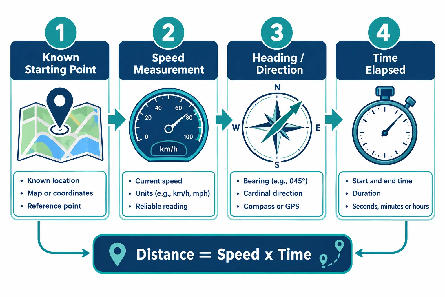
The word “reckoning” comes from an older English term meaning calculation or accounting. The “dead” part is widely believed to derive from the abbreviation “ded.”, short for “deduced”, as in deduced reckoning. Sailors in the Age of Exploration used this method to cross oceans before any electronic navigation existed. The method has not changed fundamentally since then.
Here is how it works in practice:
- Establish a known starting point. This could be a trailhead, a mapped road intersection, a dock, or any verifiable location on your map.
- Set your heading. Use a compass to determine and maintain a specific bearing or direction of travel.
- Measure your speed. On foot, the average adult walks roughly 3 miles per hour on flat terrain. On water, use a GPS log, paddle stroke count, or engine RPM. In a vehicle, use the speedometer.
- Track elapsed time. A watch, phone timer, or counting paces all work.
- Calculate distance traveled. Distance = Speed x Time. If you walk at 3 mph for 2 hours, you have covered approximately 6 miles.
- Plot your new estimated position. On a map, measure 6 miles in the direction of your bearing from your starting point. That is your dead reckoning fix.
The process repeats continuously. Each new estimated position becomes the starting point for the next calculation.
Why Is It Called Dead Reckoning
The name has confused navigators for centuries. The most credible explanation is that “dead” is a shortened form of “ded.”, an abbreviation for “deduced.” So dead reckoning is, at its core, deduced reckoning: a position deduced from known data rather than directly observed.
A secondary theory suggests the term comes from the phrase “by the dead”, meaning by the ship’s log (a device dragged behind a vessel to measure speed through the water). Neither origin is definitively proven, but the “deduced reckoning” explanation is the most widely accepted among navigation historians.
Regardless of etymology, the name stuck because the method works. Navigators who understood it survived long ocean voyages. Those who didn’t, often didn’t return.
The math behind dead reckoning is straightforward. Three variables drive every calculation: speed, heading, and time.
Core formula:
Distance = Speed x Time
Applied example:
| Variable | Value |
|---|---|
| Starting position | Known map coordinate |
| Heading | 045 degrees (northeast) |
| Speed | 3 mph (walking pace) |
| Time traveled | 1.5 hours |
| Distance covered | 4.5 miles |
| New estimated position | 4.5 miles northeast of start |
On a topographic map, you would use a ruler and the map’s scale to measure 4.5 miles along a 045-degree bearing from your starting point. That intersection is your dead reckoning fix.
Pace counting on foot: Many experienced navigators count paces rather than watch the clock. On flat terrain, most adults cover 100 meters in approximately 65-70 double paces (each time the same foot hits the ground). This varies by terrain, load, and individual stride. Calibrate your own pace count before relying on it.
Accounting for drift: Wind, current, and terrain deviation push you off your intended heading. A sailor drifting 10 degrees off course over 50 nautical miles ends up nearly 9 miles from the intended destination. Always factor in known drift when calculating.
Dead Reckoning vs GPS: Which Is More Accurate
GPS is significantly more accurate than dead reckoning under normal operating conditions. Modern GPS receivers can pinpoint your location within 3-5 meters. Dead reckoning over the same distance may accumulate errors of hundreds of meters or more, depending on how carefully speed and heading are tracked.
That said, the comparison misses the point for preppers. GPS depends on satellites, batteries, and an unobstructed signal. Dead reckoning depends on a compass, a watch, and your own judgment. In a grid-down scenario, after an EMP event, or in a dense canyon where satellites can’t reach, GPS fails completely. Dead reckoning does not.
Choose GPS if: You need precision, you have power, and the infrastructure is intact.
Choose dead reckoning if: Electronics are unavailable, batteries are dead, signals are jammed, or you’re operating in a long-term grid-down situation.
The smarter approach is to use both. GPS for precision when available, dead reckoning as the fallback that never requires charging.
When GPS goes down, dead reckoning is the most practical immediate replacement for most preppers. This is exactly the scenario that makes learning this skill worth the investment of time.
GPS can fail or become unreliable in several real-world situations:
- EMP or solar flare events that disable electronics (see the EMP hardened solar generator guide for context on electronics vulnerability)
- Battery failure in the field
- GPS jamming, which has been documented in conflict zones and can affect civilian devices
- Dense terrain such as deep canyons, heavy forest canopy, or underground passages
- Signal spoofing, where GPS coordinates are deliberately falsified
In any of these situations, a navigator with dead reckoning skills can continue moving with confidence. The key is to have already established a known position before the GPS failed, and to have noted the time, heading, and speed at that moment.
For preppers building a bug out plan, dead reckoning should be practiced on your planned routes before any emergency occurs. Knowing the terrain and your own pace count on that specific ground makes the skill far more reliable when it counts.
How Do Pilots Use Dead Reckoning
Pilots use dead reckoning as a foundational navigation technique, especially in small aircraft where avionics may be limited or when flying under visual flight rules (VFR). The process in aviation follows the same core logic as ground navigation, with adjustments for airspeed and wind correction.
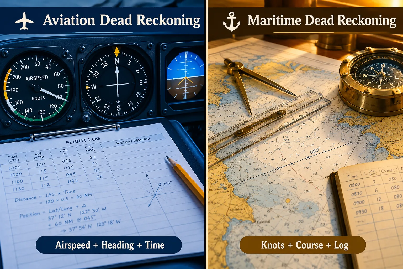
A pilot practicing dead reckoning will:
- Note the aircraft’s last confirmed position (a known waypoint, airfield, or landmark)
- Set a compass heading toward the destination
- Apply a wind correction angle to account for crosswind drift
- Calculate estimated time en route using true airspeed and distance
- Monitor elapsed time and adjust for any observed drift
True airspeed vs ground speed: An aircraft flying at 120 knots true airspeed into a 20-knot headwind has a ground speed of only 100 knots. Dead reckoning calculations in aviation must use ground speed, not airspeed, to accurately estimate position.
The FAA still requires student pilots to demonstrate dead reckoning competency as part of private pilot certification. This is not a historical curiosity, it is a required skill because instruments fail.
Maritime dead reckoning is the oldest practical application of this technique. Sailors have used it for thousands of years to cross open water without visible landmarks.
On a vessel, the navigator tracks:
- Course steered (compass heading)
- Speed through water (measured by a ship’s log or GPS speed)
- Time underway
- Current and leeway (drift caused by ocean currents and wind)
The navigator plots each leg of the voyage on a nautical chart, advancing the ship’s estimated position at regular intervals. The more frequently the position is updated, the smaller the accumulated error.
Leeway is a particular challenge in sailing. A sailboat moving at 5 knots on a heading of 270 degrees (due west) in a northerly wind may actually be tracking 10-15 degrees south of that heading due to wind pressure on the hull and sails. Experienced maritime navigators factor leeway into every calculation.
Modern commercial vessels use GPS as the primary navigation tool, but maritime law and professional certification standards still require navigators to demonstrate proficiency in traditional methods including dead reckoning. The reason is simple: electronics fail at sea, and the consequences of not knowing where you are can be fatal.
Dead Reckoning in Aviation vs Sailing: Key Differences
Both aviation and maritime dead reckoning share the same core principles, but the operating environments create meaningful differences.
| Factor | Aviation | Maritime |
|---|---|---|
| Speed range | 80-200+ knots typical | 2-20 knots typical |
| Primary drift factor | Wind correction angle | Current and leeway |
| Time scale | Minutes to hours | Hours to days |
| Error consequence | Rapid, severe | Gradual, manageable |
| Position update frequency | Every 5-15 minutes | Every 30-60 minutes |
| Key instrument | Directional gyro / compass | Magnetic compass / chart |
The most significant difference is the time available to correct errors. A pilot traveling at 150 knots has very little margin before a navigation error becomes a fuel or terrain emergency. A sailor at 5 knots has more time to recognize and correct drift before it becomes critical.
For preppers, the maritime model is more directly applicable to on-foot or vehicle navigation. The aviation model’s discipline around frequent position updates is worth adopting regardless of the medium.
What Equipment Do You Need for Dead Reckoning
The minimum equipment for dead reckoning is a compass, a map, a watch, and a way to measure or estimate speed. Everything else is an enhancement.
Minimum kit:
- Baseplate compass with a rotating bezel and degree markings
- Topographic map of the area (1:24,000 scale for foot travel)
- Watch or timer (analog watches work without batteries if mechanical)
- Pencil and notepad for logging headings, times, and calculations
Enhanced kit:
- Protractor or military pace counter for more precise map work
- Altimeter to confirm elevation and cross-check position
- Pedometer or GPS odometer for speed verification while it functions
- Parallel ruler or plotting tools for chart work on water
This is one of the most accessible survival skills from a gear standpoint. A quality baseplate compass costs between $15 and $60. A topographic map is available for free from the USGS or for a few dollars in print. The skill itself costs nothing but practice time.
If you’re building a 72-hour bug out bag, a compass and printed topographic maps of your region should be on that list. For a deeper look at navigation without electronics, the complete beginner’s guide to navigation without GPS covers the full toolkit.
Common Mistakes People Make With Dead Reckoning
Dead reckoning errors are cumulative. A small mistake early in a route compounds into a large positional error by the end. Knowing the most common failure points helps prevent them.
Mistake 1: Not establishing a firm starting position. Dead reckoning is only as good as its origin point. Starting from an estimated or guessed location multiplies every subsequent error.
Mistake 2: Ignoring magnetic declination. Magnetic north and true north differ by several degrees depending on your location. In the western United States, declination can exceed 15 degrees east. Failing to correct for this means your compass bearing and your map bearing don’t match, and your plotted course will drift accordingly.
Mistake 3: Assuming a constant speed. Uphill terrain, heavy loads, and fatigue all reduce walking speed significantly. Recalibrate speed estimates when conditions change.
Mistake 4: Not updating the position fix frequently enough. The longer the interval between position updates, the larger the potential error. Update your estimated position every 30-60 minutes at minimum when on foot.
Mistake 5: Trusting a single method. Dead reckoning works best when combined with terrain association (matching visible features to the map) and occasional celestial references. Relying solely on dead reckoning over long distances without any cross-checks is how navigators get lost.
Mistake 6: Failing to account for deviation. Obstacles force detours. Every time you leave your planned bearing to go around something, you must record the new heading, the time spent on it, and then calculate the correction needed to return to your intended track.
Dead Reckoning Drift and Error Accumulation
Error accumulation is the fundamental limitation of dead reckoning. Every small inaccuracy in speed, heading, or time measurement adds up over distance. This is called drift, and managing it is the core discipline of the technique.
How drift compounds:
- A heading error of just 1 degree results in a lateral displacement of approximately 1.75 meters per 100 meters traveled.
- Over 10 kilometers, that same 1-degree error produces a displacement of roughly 175 meters.
- Over 50 kilometers, the error grows to nearly 875 meters, almost a full kilometer off target.
Strategies to minimize drift:
- Take frequent position fixes using terrain features when they are visible
- Use back-bearings to verify your heading against a known landmark behind you
- Cross-check your estimated position against elevation data from an altimeter
- On water, use celestial navigation (sun, stars) to periodically reset your position
The military has long recognized drift as the primary weakness of dead reckoning. Modern inertial navigation systems used in submarines and aircraft use dead reckoning principles but incorporate accelerometers and gyroscopes to detect and correct drift automatically. For preppers without that technology, discipline and frequent checking are the equivalent.
How Accurate Is Dead Reckoning Over Long Distances
Over short distances (under 5 miles on foot), a careful navigator can achieve accuracy within a few hundred meters. Over long distances, accuracy degrades significantly without periodic corrections.
Realistic accuracy benchmarks for foot travel:
- Under 3 miles with careful technique: 50-150 meter error typical
- 3-10 miles with corrections: 200-500 meter error typical
- 10+ miles without landmark checks: Error can exceed 1 kilometer
Maritime navigators historically accepted errors of 1-5% of total distance traveled as reasonable for dead reckoning without celestial corrections. A 500-nautical-mile voyage might end with a 5-25 mile positional error, manageable when approaching a coastline, dangerous when threading a narrow channel.
For preppers, the practical takeaway is this: dead reckoning is reliable enough to get you to a general area, but not precise enough to find a specific building or cache without additional navigation methods. Plan your routes to terminate at large, unmistakable features (a river, a ridgeline, a road) rather than a single GPS coordinate.
Can You Use Dead Reckoning Without Instruments
Yes, dead reckoning is possible without formal instruments, though accuracy decreases. Experienced outdoorspeople have navigated successfully using only natural references and body-based measurements.
Without a compass: Use the sun’s position (rises roughly east, sets roughly west), star navigation (Polaris indicates true north in the Northern Hemisphere), or shadow-tip methods to establish a rough heading. This introduces significant heading error but is better than no reference at all.
Without a watch: Estimate time using the sun’s movement (roughly 15 degrees per hour across the sky), or count paces to measure distance directly rather than calculating from speed and time.
Without a map: Mental mapping, building a detailed mental model of terrain features, distances, and directions traveled, is a practiced skill. It is less reliable than paper maps but has been used by indigenous navigators, military scouts, and experienced wilderness travelers for centuries.
The more instruments you have, the more accurate your dead reckoning will be. But the absence of instruments does not make the method useless. It just requires more careful observation and more frequent cross-checks with the environment around you. This is one reason wilderness survival skills that include natural navigation are worth developing alongside instrument-based techniques.
Is Dead Reckoning Still Used Today
Dead reckoning remains an active, required skill in aviation, maritime navigation, military operations, and space exploration. It is not a historical relic, it is a living technique that modern systems still depend on.
- Aviation: The FAA requires private pilot candidates to demonstrate dead reckoning competency. Commercial pilots use it as a backup when avionics fail.
- Maritime: Professional maritime certification programs worldwide include dead reckoning as a core competency. SOLAS (the International Convention for the Safety of Life at Sea) mandates that vessels carry the means to navigate without electronic aids.
- Military: Ground navigation training in most military forces worldwide includes dead reckoning as a fundamental land navigation skill.
- Space: NASA and other space agencies use inertial navigation, a sophisticated electronic form of dead reckoning, to track spacecraft position when direct communication is unavailable.
- Autonomous vehicles: Self-driving cars use dead reckoning algorithms (combining wheel speed sensors and gyroscopes) to maintain position estimates when GPS signals are lost in tunnels or urban canyons.
The skill is not obsolete. It is the foundation that more advanced systems are built on.
FAQ
What is the simplest definition of dead reckoning?
Dead reckoning is estimating your current position by starting from a known location and calculating forward using your speed, direction, and the time you’ve been traveling. No GPS or external reference is needed.
How accurate is dead reckoning on foot?
With careful technique over short distances (under 3 miles), a trained navigator can stay within 50-150 meters of their actual position. Accuracy degrades over longer distances without periodic corrections from terrain features or landmarks.
What does “dead” mean in dead reckoning?
Most navigation historians believe “dead” is derived from “ded.”, an abbreviation for “deduced.” Dead reckoning is deduced reckoning: a position deduced from calculations rather than direct observation.
Can dead reckoning work without a compass?
Yes, but with reduced accuracy. The sun, stars, and shadow methods can provide rough directional references. Pace counting can replace a watch for distance measurement. The method works without instruments, but errors increase substantially.
What is the biggest source of error in dead reckoning?
Heading error is typically the largest single source of drift. Even a 1-2 degree error in compass bearing compounds into significant positional error over distance. Magnetic declination correction is one of the most commonly skipped steps and one of the most consequential.
Do pilots still learn dead reckoning?
Yes. The FAA requires student pilots to demonstrate dead reckoning proficiency as part of private pilot certification. It remains a required backup skill because avionics and GPS can and do fail in flight.
How often should I update my dead reckoning position?
On foot, update your estimated position every 30-60 minutes or whenever you pass a recognizable terrain feature. In aircraft, every 5-15 minutes. The more frequently you update, the smaller your accumulated error.
What is the difference between dead reckoning and pilotage?
Pilotage is navigating by visual reference to landmarks and terrain features. Dead reckoning is navigating by calculation. In practice, skilled navigators combine both: pilotage to confirm and reset position, dead reckoning to maintain it between landmarks.
Is dead reckoning useful in urban environments?
Yes. In a city, you can use block counts, known street distances, and compass headings to track your position even without GPS. Urban preppers can apply dead reckoning principles to navigate during power outages or communications blackouts.
What is leeway in maritime dead reckoning?
Leeway is the sideways drift of a vessel caused by wind pressure on the hull and sails. It causes the actual track of the vessel to differ from the compass heading being steered. Experienced sailors estimate leeway angle and factor it into their course calculations.
How do I practice dead reckoning as a prepper?
Start in a familiar area. Set a compass bearing, walk for a measured time at a known pace, then calculate where you should be and check it against your map. Gradually extend the distances and add terrain challenges. Practice on your planned bug-out routes specifically.
What is the minimum gear needed for dead reckoning?
A baseplate compass, a topographic map of your area, a watch, and a pencil. That is the complete minimum kit. Everything else is optional enhancement.
Conclusion
Dead reckoning navigation is not a skill from the past, it is a skill for the future that preppers cannot afford to ignore. When GPS satellites are unavailable, when batteries die, when an EMP event takes down the grid, or when you’re simply deep in terrain where no signal reaches, dead reckoning is what keeps you moving in the right direction.
The method is learnable by anyone willing to practice it. The gear costs almost nothing. The knowledge, once built, never requires charging.
Actionable next steps:
- Purchase a quality baseplate compass and download or print topographic maps of your region.
- Calibrate your personal pace count on flat terrain and on slopes.
- Practice a dead reckoning route in a familiar area before attempting it in unfamiliar terrain.
- Learn the magnetic declination for your area and practice correcting for it consistently.
- Add dead reckoning practice to your planned bug-out routes so the skill is tested on the ground you’ll actually use it on.
Navigation is one of the most critical wilderness survival skills a prepper can develop. Pair dead reckoning with terrain association, celestial navigation basics, and a solid survival skills checklist and you will have a navigation system that works regardless of what technology fails around you.
Products, Tools, and Resources
Suunto A-10 Baseplate Compass, A reliable, affordable entry-level compass with clear baseplate, rotating bezel, and degree markings. Suitable for land navigation and dead reckoning practice. Available at most outdoor retailers.
USGS Topographic Maps, Free digital downloads available at usgs.gov. Print the 1:24,000 scale maps for your region and laminate them for field use.
Brunton TruArc5 Compass, A step up from basic models, with global needle balance and a more precise bezel. Good choice for preppers who want a durable long-term tool.
Silva Ranger 2.0, A full-featured compass with a mirror sighting system for more precise bearing work, useful for longer-distance dead reckoning where heading accuracy is critical.
Waterproof field notebook (Rite in the Rain), Essential for logging headings, times, and calculations in the field. Standard paper fails in rain; these do not.
“Wilderness Navigation” by Bob Burns and Mike Burns, A practical, well-regarded guide to map and compass skills including dead reckoning, published by The Mountaineers Books. Widely used in outdoor education programs.
For preppers building a complete navigation toolkit, also review the bug out bag mistakes to avoid, navigation gear omissions are among the most common and most dangerous gaps in a bug-out kit.